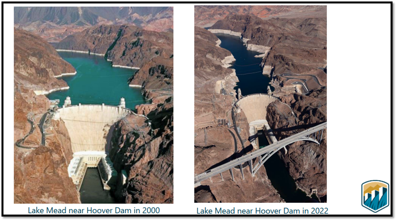
First and foremost, it should be stated at the outset that one time the City of Prescott had a Colorado River contract, but no longer. In 1983, the Secretary of the Interior of the Bureau of Reclamation allocated to the City 7,127 acre-feet of Municipal and Industrial Water, and in 1992, Prescott, the United States, and the Central Arizona Water Conservation District (CAWCD) agreed to a subcontract with the City in allow Prescott to grow and develop. Due to the impracticality of installing infrastructure that would have to be pumped uphill, the City considered an exchange of its Central Arizona Project (CAP) water contract for water from the Verde River, but environmental concerns and litigation ensued, preventing utilization of this source. In 1996, the City sold its CAP allocation to the City of Scottsdale for a little over $7Million.
Even though the City is no longer entitled to this allocation, it is still important to understand the “law of the river” which governs senior rights on the Colorado, and the 40 million people who rely on it.
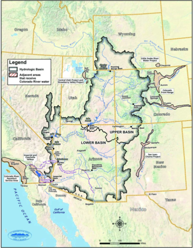
Both the Upper Basin States and Lower Basin States were each allocated 7.5 million acre-feet (MAF), but this determination was made during the wet years from 1906 to 1921, when there was approximately 18 MAF in the River.
Of the 7.5 MAF apportioned by the BOR to the Lower Basin States, California receives 4.4 MAF, Arizona 2.8 MAF, and Nevada 0.3 MAF. (Evidently years ago no one anticpated the growth spurt in Nevada.)
From 1906 to 2020, natural flow was down to 14.7 MAF, and from 2000 to 2020, ~12.5 MAF stemmed from natural flow.
Unfortunately, this coincides with the drought that began in 2000 – the worst drought in 1,200 years.
A presentation by the Bureau of Reclamation (BOR) at the Water Utility Leadership Forum (WULF) in Flagstaff on May 19, 2023, orchestrated by Northern Arizona Municipal Water Users Association (NAMWUA), provided information on the Bureau’s responsibilities. The BOR has been tasked with the following Management Objectives:
- Provide flood control and river regulation
- Meet US Water orders
- Meet water delivery and salinity requirements under the 1944 U.S.-Mexico Water Treaty and Minutes
- Generate hydropower
- Implement LCR Multi-Species Conservation Program
- Supports recreational opportunities.
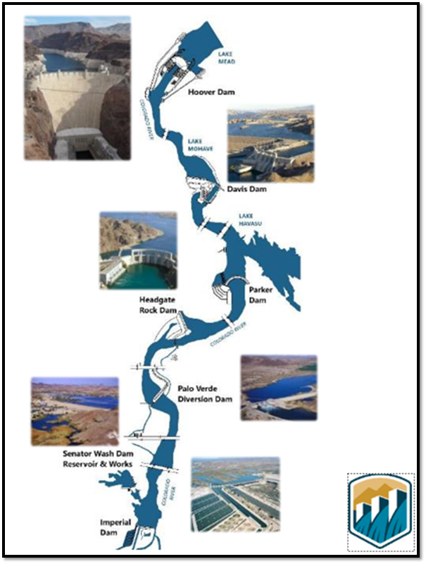
These Lower Basin dams are regulated by the BOR.
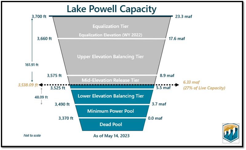
As of May 14, 2023, the elevation of Lake Powell was at 3,538.09 feet; at 6.33 MAF, that is only 27% of capacity. This should improve, however, as the mountain snows melt.
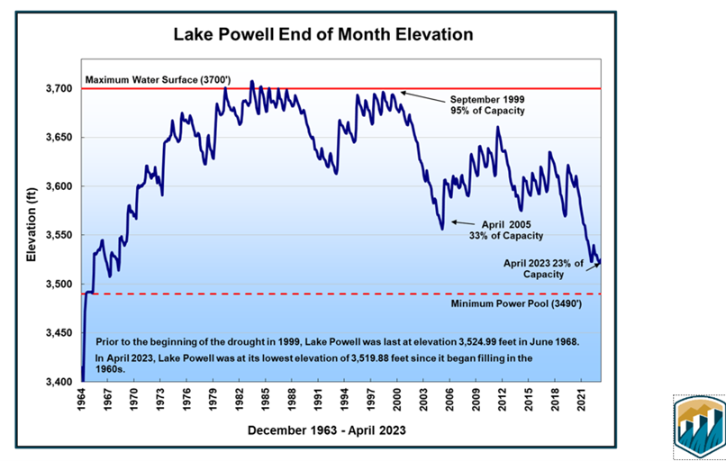
This graph indicates that in June 1968, Lake Powell was at an elevation of 3,524.99 feet, only 524.99 feet above the Mininimum Power Pool elevation of 3,490 feet, signifying droughts are cyclical. In September 1999, the elevation of Lake Powell was at 99% capacity. By April of 2023, the elevation is only 23% of capacity.
Regardless, the snowpack has had a positive impact on elevations at both Glen Canyon Dam, which forms Lake Powell, and Hoover Dam, which creates Lake Mead. Lake Powell, which is mostly in Utah but extends into Arizona, is designed to collect water from the Upper Basin of the Colorado River. Lake Mead, which straddles the border between Nevada and Arizona, is filled by releases from Lake Powell.
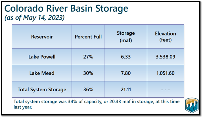
The table above indicates that as of May 14, 2023, there has been a slight increase in elevation at Lake Powell, 27%, from the April 2023 low of 23%. Note that the total system storage was at 34% capacity at this time last year.
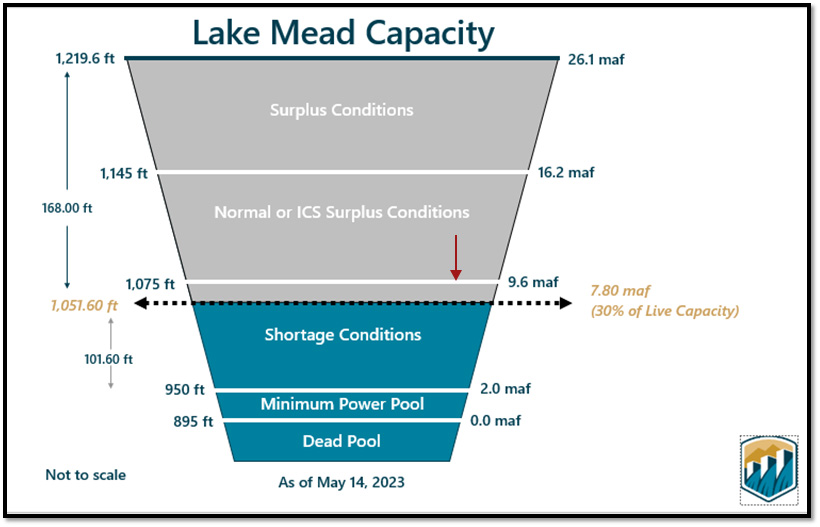
In January 2022, the Bureau of Reclamation declared a Tier 1 shortage at Lake Mead when the 1,075-foot elevation was reached. (See red arrow.) As of May 14, 2023, the elevation of Lake Mead was 1,051.60 feet. An elevation of 1,050 feet will trigger a Tier 2a shortage, and an elevation of 1,045 feet will trigger a Tier 2b shortage.
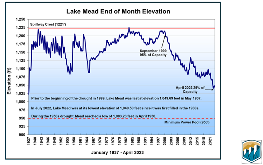
This graph illustrates that Lake Mead was at an elevation of 1,049.69 feet in May 1937. During the 1950s drought, Lake Mead reached an elevation low of 1,083.23 feet. By July 2022, Lake Mead reached its lowest elevation of 1,040.50 feet. As of May 14, 2023, Lake Mead is at 30% capacity.
The Arizona Municipal Water Users Association (AMWUA) is comprised of ten Valley cities: Peoria, Phoenix, Scottsdale, Glendale, Avondale, Tempe, Mesa, Gilbert, Chandler, and Goodyear. In a May 30, 2023, AMWUA blog, Lake Powell had an “unexpected 151% above-average water flow…the second-highest projected runoff since the historic drought began in 2000.” This is great news! But this amount of snowpack is a temporary reprieve for all users of Central Arizona Project Water and is still a short-term remedy.
An agreement was reached on May 22nd among the lower basin states of California, Arizona, and Nevada to conserve 3 MAF over a three-year period. According to AMWUA, five municipalities, Phoenix, Glendale, Peoria, Scottsdale, and Gilbert have made commitments to leave 1.15 MAF of water over the next four years in the Colorado River system. The chart below shows the contribution of each of the three states.

In the meantime, the federal government will provide some form of assistance to many of the downstream users.
What will happen at the end of the fourth year, in 2026? This allows time for Reclamation to propose new 2026 Guidelines, recognizing that all Upper and Lower Basin State users of an overallocated resource must come together to make compromises and reductions.
